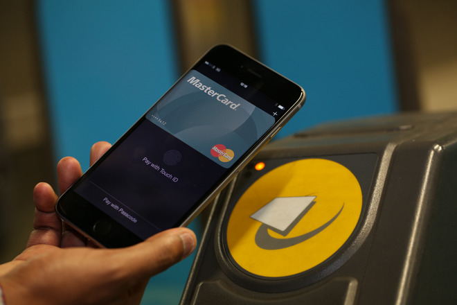
Ditching your SmartCard and replacing it with your smartphone could be the future of public transportation in Alexandria.
Alexandria’s DASH bus is testing a mobile payment app during Metro’s summer long closure of Blue and Yellow Line stations south of Reagan National Airport, which will start next weekend.
Continue reading
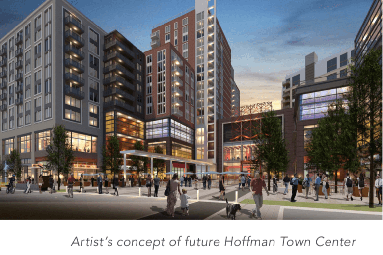
The Washington Metropolitan Area Transit Authority known as Metro is seeking to reduce its office buildings from ten (10) to four (4) with the proposal of a new regional headquarters to be located in Alexandria. The new building will be built on land already owned by Metro. The new headquarters in Alexandria will be located at 2395 Mill Road which is adjacent to the Hoffman Town Center Development and closely located to the Eisenhower Avenue Station.
Continue reading
The independent city of Alexandria located in the state of Virginia is known as George Washington's hometown. Alexandria is also known for being rich with colonial history. Alexandria is located approximately 11 km south of downtown Washington, D.C. As of the 2018 census, the population was 160,035 which grew by 1.75% from the previous year.
Due to the proximity of Alexandria to the capital of the United States, majority of professionals are working to serve the US military, federal civil service, or private companies which provide contractual work to the federal government. Some of the major employers found in Alexandria are the United States Department of Defense, United States Department of Commerce, Institute of Defense Analyses, United States Patent and Trademark Office, and the National Science Foundation.
Alexandria's historic train station, Alexandria Union Station, has an Amtrak train which offers intercity services. Alexandria also has the Virginia Railway Express which offers regional rail services. Braddock Road, Eisenhower Avenue, and Van Dorn Street are three other stations located in Alexandria. The DASH bus, Alexandria's own mass transit system, connects interest points with local transit hubs. Alexandria also offers free bus services between the waterfront and the King Street Metro Station.
In terms of school ranking, Waynewood Elementary School came in first in the elementary level followed by Lyles-Crouch Elementary and Charles Barrett Elementary School. For middle school, Hayfield Secondary and Twain Middle School are the top schools. Lastly, for high school, Thomas Jefferson High for Science and Technology and Hayfield Secondary are the top schools.
Arlington Oaks has a location in Arlington VA which is less than a mile to Ballston Metro.
Arlington Oaks in Arlington
A plus is that it offers community amenities such as pool and tennis court. Arlington Oaks is nestled close to Route 50.
Condos in Arlington Oaks were built in 1940 and they cost between $218,000 to $390,000 each. This condo community is served by the following schools: Barrett Elementary School, Swanson Middle School and Washington-Lee High School.
Arlington Oaks in Arlington VA is conveniently located close to commuting routes, shopping, and metro bus.
Arlington Oaks are a traditional style condo setting with a substantial exterior. This location is pertinent for those seeking residence near the capitol. This spot can be a good choice for newcomers to the city.
Arlington Oaks sports easy access to the Ballston Common Shopping Center, Regal Cinemas Ballston Common Stadium 12, Kettler Capitals Iceplex, and Welburn Square.
The Hawthorn combines urban sophistication and modern elegance with convenient on-site amenities. The Hawthorn is located at 820 N Pollard Street, Ste 102 Arlington, VA 22203.
Nesbitt Realty can help you buy and sell real estate in 22203.The Hawthorn provides a full palate of amenities, services and security. Highlights include:
The metro comes in frequent intervals, especially during the morning and evening, the times when people are going to or returning from work
Did you know that that the Washington Metro Transit Authority (WMATA) offers a free, web-based service called the Trip Planner? Using Trip Planning you can instantly learn accurate and timely information about metro buses and trains to schedule your next trip. The Trip Planner will offer the best route(s) to take to get there and include fare information and walking directions from a Metrorail station or bus stop to a given address.
If you're seeking a home on the Metro, you might find our search by station resource particularly helpful.
Are you looking for a home or condo near a metro station? Use our site to find properties close to Metro stations.
Will and Julie Nesbitt cross the street in Shirlington
Walk Score helps people find walkable places to live. Walk Score calculates the walkability of an address by locating nearby stores, restaurants, schools, parks, etc. Walk Score promises to measure how easy it is to live a car-lite lifestyle---not how pretty the area is for walking.
Each home listed for sale is given a Walk Score. That number is between 0 and 100. Here are general guidelines for interpreting your score:
90–100 = Walkers' Paradise: Most errands can be accomplished on foot and many people can get by without owning a car.
70–89 = Very Walkable: It's possible to get by without owning a car.
50–69 = Somewhat Walkable: Some stores and amenities are within walking distance, but many everyday trips still require a bike, public transportation, or car.
25–49 = Car-Dependent: Only a few destinations are within easy walking range. For most errands, driving or public transportation is a must.
0–24 = Car-Dependent (Driving Only): Virtually no neighborhood destinations within walking range. You can walk from your house to your car!
Walk Score isn't perfect ...
Home buyers need to be aware that Walk Score is just an approximation of walkability.
Walking to a restaurant on a Fall evening in Del Ray
For example, the Skyline communities of Falls Church generally have a higher Walk Score than the New Alexandria community of Belle View. River Towers has pleasant tree-lined walkways with easy access to neighborhood shops, parks, libraries, the Potomac. Skyline Square is convenient as can be, but broad and busy 4 lane roads make walking inconvenient, if not dangerous. But River Towers doesn't score as high on Walk Score as Skyline Square.
So, there are a number of factors that contribute to walkability that are not part of the algorithm used to calculate Walk Score:
Public transit: Good public transit is important for walkable neighborhoods. Not to fear: you can also search for homes near a metro station.
Street width and block length: Narrow streets slow down traffic. Short blocks provide more routes to the same destination and make it easier to take a direct route.
Street design: Sidewalks and safe crossings are essential to walkability. Appropriate automobile speeds, trees, and other features also help.
Safety from crime and crashes: How much crime is in the neighborhood? How many traffic accidents are there? Are streets well-lit?
Pedestrian-friendly community design: Are buildings close to the sidewalk with parking in back? Are destinations clustered together?
Topography: Hills can make walking difficult, especially if you're carrying groceries.
Freeways and bodies of water: Freeways can divide neighborhoods. Swimming is harder than walking.
Weather: In some places it's just too hot or cold to walk regularly.
Walking near Cameron Mews in Old Town Alexandria
Thus, the tools on our site are a great starting point in your search for homes and neighborhoods of Northern Virginia, but there really is no substitute for your Condo Alexandria realtor. We know the areas and neighborhoods where you want to live and we can really help you sort to the wheat from the chaff.
The average American spent a total of 28 hours sitting in traffic last year, according to INRIX, a traffic information group. But residents in some of the nation’s most congested cities spent nearly double that—an average of 42 hours a year—sitting in traffic.
In its 2012 Traffic Scorecard, INRIX compared the average of the drivers’ actual speed on the road during peak hours with the average speed of drivers when there was no congestion.
Here are the 10 cities with the worst traffic, according to the study:
1. Los Angeles
Congestion score: 28.8
Average commute time: 28.6 minutes (15th highest)
2. Honolulu
Congestion score: 26
Average commute time: 27 minutes (the 27th highest)
3. San Francisco
Congestion score: 23.5
Average commute time: 29.2 minutes (tied for 10th highest)
4. Austin
Congestion score: 20.7
Average commute time: 25.8 minutes (45th highest)
5. New York
Congestion score: 19.9
Average commute time: 34.9 minutes (the highest)
6. Bridgeport, Conn.
Congestion score: 19.1
Average commute time: 28.3 minutes (18th highest)
7. San Jose, Calif.
Congestion score: 17.6
Average commute time: 24.8 minutes (65th highest)
8. Seattle
Congestion score: 17.6
Average commute time: 27.6 minutes (22nd highest)
9. Washington, D.C.
Congestion score: 16.4
Average commute time: 34.5 minutes (2nd highest)
10. Boston
Congestion score: 14.7
Average commute time: 29.2 minutes (tied for 10th highest)
Source: “10 Cities With the Worst Traffic,” USA Today (May 4, 2013)
DASH (Driving Alexandrians Safely Home) buses are seen around, across and near the city of Alexandria, Virginia. The City of Alexandria wholly owns the DASH bus system and operates the system as a non-profit public service cooperation. But day to day management of the system is provided by Alexandria Transit Company.
If you're new to the area, you'll soon find out what others already know. The DASH buses are a clean, safe and effective way to get about the city. Boarding the bus is simple and easy. When the bus arrives, just step into the bus and then deposit the exact fare or use your WMATA SmarTrip card.If you have any questions about routes or transfers ask the driver and then take a seat. On some of the most popular routes or during rush hours, there might not be any available seats. In that case just move as far to the rear of the bus as possible. This makes it easier for others to board easily.
Be aware that the bus driver doesn't always stop at all bus stops! To signal to the driver that your stop is approaching, press the yellow signal strip or pull the bell cord. It's best to do this about a block from your destination so the driver has timely notice to stop at the next bus stop. When exiting the bus the rear door is easiest because others may be waiting to board through the front door.
DASH has great service because it has great employees but also because area passengers observe a few simple rules of safety and courtesy:
There is no smoking, eating, or drinking allowed on the bus.
Radios, I-pods and other devices may only be used if they cannot be heard by others
There are a limited number of priority seats that are reserved for senior citizens and disable persons. You may sit in these seats, but riders are expected to volunteer that seat if the seat is needed by a senior citizen or disabled person. If the bus is full, riders are expected to volunteer seats as needed.
All passengers keep feet off passengers' seats.
To maintain the high level of quality offered by DASH, drivers may refuse service to anyone who does not observe these rules or to anyone whose behavior is disruptive or hazardous to vehicle or passenger safety.
For more information or to set up an appointment call Stuart at (703)765-0300.
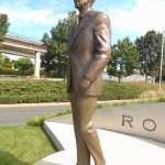
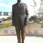
Ronald Reagan Airport is located at 1 Aviation Circle, Arlington, Virginia. The airport is close to Old Town Alexandria, inside of Arlington and near Washington DC. Ronald Reagan Airport is a primary transportation hub for Northern Virginia and DC. The next closest airport is BWI which is in Maryland.
Ronald Reagan Airport has a metro stop accessible by the blue and yellow line. Near the airport there are several trails. Further from Old Town and closer to DC there is a marina with boats. The marina waters are great for fishing.
Ronald Reagan Airport services Northern Virginia and DC
Powtomack Crossing is a condominium near Ronald Reagan Airport
Ronald Reagan Airport is close to Old Town which has many bars on King St.
Ronald Reagan Airport is a common segway for military
Ronald Reagan Airport is close to Old Town which has several parks
 Ditching your SmartCard and replacing it with your smartphone could be the future of public transportation in Alexandria.
Alexandria’s DASH bus is testing a mobile payment app during Metro’s summer long closure of Blue and Yellow Line stations south of Reagan National Airport, which will start next weekend.
Continue reading
Ditching your SmartCard and replacing it with your smartphone could be the future of public transportation in Alexandria.
Alexandria’s DASH bus is testing a mobile payment app during Metro’s summer long closure of Blue and Yellow Line stations south of Reagan National Airport, which will start next weekend.
Continue reading
 The Washington Metropolitan Area Transit Authority known as Metro is seeking to reduce its office buildings from ten (10) to four (4) with the proposal of a new regional headquarters to be located in Alexandria. The new building will be built on land already owned by Metro. The new headquarters in Alexandria will be located at 2395 Mill Road which is adjacent to the Hoffman Town Center Development and closely located to the Eisenhower Avenue Station.
 The independent city of Alexandria located in the state of Virginia is known as George Washington's hometown. Alexandria is also known for being rich with colonial history. Alexandria is located approximately 11 km south of downtown Washington, D.C. As of the 2018 census, the population was 160,035 which grew by 1.75% from the previous year.
Due to the proximity of Alexandria to the capital of the United States, majority of professionals are working to serve the US military, federal civil service, or private companies which provide contractual work to the federal government. Some of the major employers found in Alexandria are the United States Department of Defense, United States Department of Commerce, Institute of Defense Analyses, United States Patent and Trademark Office, and the National Science Foundation.
Alexandria's historic train station, Alexandria Union Station, has an Amtrak train which offers intercity services. Alexandria also has the Virginia Railway Express which offers regional rail services. Braddock Road, Eisenhower Avenue, and Van Dorn Street are three other stations located in Alexandria. The DASH bus, Alexandria's own mass transit system, connects interest points with local transit hubs. Alexandria also offers free bus services between the waterfront and the King Street Metro Station.
In terms of school ranking, Waynewood Elementary School came in first in the elementary level followed by Lyles-Crouch Elementary and Charles Barrett Elementary School. For middle school, Hayfield Secondary and Twain Middle School are the top schools. Lastly, for high school, Thomas Jefferson High for Science and Technology and Hayfield Secondary are the top schools.
The independent city of Alexandria located in the state of Virginia is known as George Washington's hometown. Alexandria is also known for being rich with colonial history. Alexandria is located approximately 11 km south of downtown Washington, D.C. As of the 2018 census, the population was 160,035 which grew by 1.75% from the previous year.
Due to the proximity of Alexandria to the capital of the United States, majority of professionals are working to serve the US military, federal civil service, or private companies which provide contractual work to the federal government. Some of the major employers found in Alexandria are the United States Department of Defense, United States Department of Commerce, Institute of Defense Analyses, United States Patent and Trademark Office, and the National Science Foundation.
Alexandria's historic train station, Alexandria Union Station, has an Amtrak train which offers intercity services. Alexandria also has the Virginia Railway Express which offers regional rail services. Braddock Road, Eisenhower Avenue, and Van Dorn Street are three other stations located in Alexandria. The DASH bus, Alexandria's own mass transit system, connects interest points with local transit hubs. Alexandria also offers free bus services between the waterfront and the King Street Metro Station.
In terms of school ranking, Waynewood Elementary School came in first in the elementary level followed by Lyles-Crouch Elementary and Charles Barrett Elementary School. For middle school, Hayfield Secondary and Twain Middle School are the top schools. Lastly, for high school, Thomas Jefferson High for Science and Technology and Hayfield Secondary are the top schools.


 If you're new to the area, you'll soon find out what others already know. The DASH buses are a clean, safe and effective way to get about the city. Boarding the bus is simple and easy. When the bus arrives, just step into the bus and then deposit the exact fare or use your WMATA SmarTrip card.If you have any questions about routes or transfers ask the driver and then take a seat. On some of the most popular routes or during rush hours, there might not be any available seats. In that case just move as far to the rear of the bus as possible. This makes it easier for others to board easily.
Be aware that the bus driver doesn't always stop at all bus stops! To signal to the driver that your stop is approaching, press the yellow signal strip or pull the bell cord. It's best to do this about a block from your destination so the driver has timely notice to stop at the next bus stop. When exiting the bus the rear door is easiest because others may be waiting to board through the front door.
DASH has great service because it has great employees but also because area passengers observe a few simple rules of safety and courtesy:
If you're new to the area, you'll soon find out what others already know. The DASH buses are a clean, safe and effective way to get about the city. Boarding the bus is simple and easy. When the bus arrives, just step into the bus and then deposit the exact fare or use your WMATA SmarTrip card.If you have any questions about routes or transfers ask the driver and then take a seat. On some of the most popular routes or during rush hours, there might not be any available seats. In that case just move as far to the rear of the bus as possible. This makes it easier for others to board easily.
Be aware that the bus driver doesn't always stop at all bus stops! To signal to the driver that your stop is approaching, press the yellow signal strip or pull the bell cord. It's best to do this about a block from your destination so the driver has timely notice to stop at the next bus stop. When exiting the bus the rear door is easiest because others may be waiting to board through the front door.
DASH has great service because it has great employees but also because area passengers observe a few simple rules of safety and courtesy: