Creative Commons License photo credit: CrimsonMage
The Potomac River is located on the east coast of the United States, and runs through Maryland, Virginia, West Virginia, and Washington, D.C. before it empties into the Chesapeake Bay. It is over 380 miles long and wider than 11 miles at its widest point.
As it passes through Washington DC, the nation's capital, the Potomac passes the Washington Monument and the memorials of Jefferson, and Lincoln. Many consider the Potomac to be one of the most beautiful and bountiful rivers on the East Coast. The river is also widely regard its historic, scenic and recreational significance. Among the many who loved the Potomac was George Washington, who worked as a surveyor at many points along the banks of the river. George Washington's mansion
at Mount Vernon is on the Potomac.
Mount Vernon, George Washington's estate on the Potomac
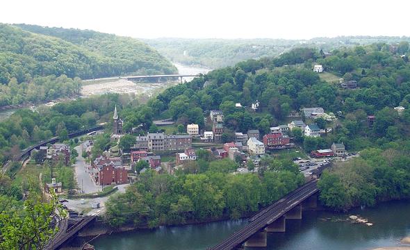
The Potomac's source is a small spring at the Fairfax Stone in West Virginia. From there, the river gathers many tributaries, winding through the mountains and valleys of Appalachia. One of its most
dramatic turns occurs at Harper's Ferry where the Shenandoah meets the
Potomac.
At Great Falls, the Potomac tumbles down from the Appalachian Highlands to the sandy soils of the Atlantic Coastal Plain. Visitors from the colonial era to the modern era relish the views here. Today visitors at Great Falls
will not only marvel at the cataracts, but also the engineering efforts of those who sought to fulfill George Washington's dream of connecting the Chesapeake Bay to the Ohio River. The C & O Canal was only operational for a few short years, but remnants of the system are still functional at Great Falls Park.
Finally, the river flows almost 400 miles widening to over 11 miles as it reaches the Chesapeake Bay on the long, low, and barren peninsula named Point Lookout, Maryland. Before the US Civil War, Point Lookout was home to a few hotels and boarding houses, but during the war it was converted into one of the largest and worst of the Union
prisoner-of-war camps.
Fishers, anglers, boaters, sailors and kayakers all enjoy the Potomac.
The Potomac River has a watershed of 14,670 square miles including tributaries in Maryland (the Monocacy, Savage, and St. Mary's Rivers); in Virginia (the Shenandoah and Occoquan Rivers); in West Virginia (the South Branch and Cacapon Rivers); in Pennsylvania (Conococheague and Antietam Creeks); and in Washington DC (the Anacostia River). The Potomac cradles forests, battlefields, farmlands, mountains, parks, and cities. It is known to many as our Nation's River.
If you're searching for a home or condo in Northern Virginia with a view of the Potomac, contact Will Nesbitt with Condo Alexandria.
Old Town Commons is a series of town houses that cover 5 city blocks. Old Town Commons is located at the intersection of North Columbus Street and Madison Street. This is a great location with walkable features, and metro access. Old Town has several parks, a basketball court, volleyball court, and scenic waterfront views. The address is 735 N. Alfred Street Alexandria, VA 22314735.
Old Town Commons is conveniently close to shopping in Old Town. Old Town Commons is also close to the shopping area at Potomac Yard. These town homes feature rooftop terraces, garage parking, and professional landscaping. Old Town Commons is a short commute to Washington D.C.
The local airport around here is Ronald Reagon
These town houses have Energy Star labeled windows
Scott's Run
Scott's Run Nature Preserve is one of Fairfax County's most rugged parks and public areas. Scott's Run Nature Preserve is located at 7400 Georgetown Pike in McLean, just outside the Beltway near Tysons Corner and Dunn Loring. The nature preserve is named for Scott's Run, a tributary of the Potomac River. The creek springs from a very large ancient gravel deposit that is the highest altitude in Fairfax County. The point of origin is just below the parking lots of the shopping centers of Tysons Corner. Flowing east, through many business parks and condominium complexes, Scott's Run empties into the Potomac at the waterfall.
Hikers will find two entrances into the valley park. One path trails along the stream and the other path leads to the bluffs above the river. Hiking the trails of Scott's Run can be challenging and rewarding. Some trails are gentle and wind quietly through the forest. Other trails require hiking up and down very steep hills and cliffs. Be aware that the trails down the bluffs to the Potomac River are sheer in many places, and visitors must very carefully pick their way down the rocky cliffs.
“Zero-loss” of remaining County-owned natural lands
248 County-owned acres identified for preservation
Three-year inventory found seven unmapped streams, 600 native species, including 14 rare plants
ARLINGTON, VA – The Arlington County Board today approved the County’s first comprehensive plan to preserve and manage County-owned natural lands.
“By adopting this plan today, we are taking much-needed action to protect our remaining open spaces, and the plants and animals they shelter, for future generations,” County Board Chairman Jay Fisette said. “Our parks department has done an outstanding job of comprehensively mapping this County’s natural resources and giving us the information we need to preserve Arlington’s natural resource assets.”
The plan is based on an unusual, comprehensive inventory of Arlington’s natural resources carried out between 2005 and 2008 by the County Department of Parks, Recreation and Cultural Resources. The inventory found that only 4.7 percent of Arlington’s surface area — a little more than 700 acres — remains as natural lands. Of these, well over half are owned by the U.S. Park Service as part of the George Washington Memorial Parkway system. Fifty percent of all surface streams have disappeared and invasive plant species are widespread. (View presentation to the PDF, 2MB)
Highlights of the plan’s 19 recommendations for preserving and managing natural lands include:
Adopting a general policy goal of “zero-loss” of County-owned natural lands.
Developing a new GIS-based environmental review process to protect significant individual natural resources on County-owned open space.
Establishing a single, specialized management unit to manage Arlington’s natural resources.
Establishing a new administrative category of County-owned open space, or Natural Resource Conservation Areas (NRCA).
Developing an individual natural resources management plan for each County-owned park designated as a Natural Resource Conservation Area, or containing NRCAs.
The Board voted 5-0 to approve the plan.
To read more about the plan, visit the County’s website.
Arlington, Va., is a world-class residential, business and tourist location that was originally part of the "10 miles square" parcel of land surveyed in 1791 to be the Nation's Capital. It is the geographically smallest self-governing county in the United States, occupying slightly less than 26 square miles. Arlington maintains a rich variety of stable neighborhoods, quality schools and enlightened land use, and received the Environmental Protection Agency's highest award for "Smart Growth" in 2002. Home to some of the most influential organizations in the world - including the Pentagon - Arlington stands out as one of America's preeminent places to live, visit and do business.
The Lyon Park neighborhood has three parks within its boundaries. The Lyon Park parkground is located on North Pershing Drive between North Fillmore and North Garfield Streets. The community has supported the Park as a small children's playground and has maintained its charming character as such. The park is designated as dog-free.
The Park and the Community House are also host to a number of community-oriented entertainment events during the year, which help to give Lyon Park its distinctive feel as a cohesive neighborhood. Clay Park, located within Lyon Park on N. 7th Street between North Highland and North Garfield Streets, is owned and maintained by the County. It has a gazebo, a school-age playground, and an outdoor basketball court. Fillmore Park is located off North Fillmore Street between the Long Branch Elementary School and the County bike path and is also a County park. It has picnic tables, a school-age playground, and a youth baseball field.